Hebron PathsMaps of Paths and Trails
Select site maps below
 Click this icon to open a live map
Jagger Lane Open Space  Directions Directions 
Click image above to download printable map. Live map Trail Conditions:  Trail is marked. Trail is marked.
 Sturdy footwear recommended Sturdy footwear recommended Trail conditions are mostly good with a couple of muddy
places including by the entrance. Otherwise generally mown grass. Parking:  Parking in a dedicated roadside lot and on shoulder of Parking in a dedicated roadside lot and on shoulder of
Jagger Lane away from the intersection. 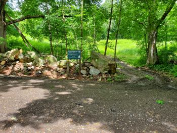
Parking area
| Information: 
 Hebron Views article 2021 Hebron Views article 2021
Also known as the old 'Way Property'. Simple paths. This 32-acre property, is "L" shaped extending along Jagger Lane from its intersection of Hardy Road to the west with approximately 1,200 feet of road frontage. It is located within the Fawn Brook Greenway. A section of the property is used for farm operations (grazing) as its primary feature is grassland. Other natural features include a picturesque shallow pond; areas of deciduous woodlands, wetlands and rolling hills, providing a scenic view of Merrow Swamp.
Merrow Swamp, a Wetlands of Statewide Special Concern, is located at the northern end of the parcel and is the headwaters of Fawn Brook, a Class A watercourse. The Property is host to Species of Special Concern at this northern end. A system of trails extends from the Jagger Lane entrance north to the property’s pond and to the Merrow Swamp at the northern end of the parcel and then winds its way to the property’s westerly end. Birding:  Get the free Merlin Bird ID app Get the free Merlin Bird ID app Look and listen out for the following species which are often found
in the Hebron woodlands. Warbling Vireo, Baltimore Orioles, Yellow Warbler, Great Crested Flycatcher, American Redstart, American Robin, Catbirds, Golden-winged Warbler, Blue Jays, Grosbeak, Tufted Titmouse, Cardinals, Carolina Wren, Blue-gray Gnatcatcher, Red-winged Blackbirds, House Wren, Grackles, Wood Thrush, Yellow-throated Vireo, Red-bellied Woodpecker, Crows, Cardinals, Bluebirds, Chickadees, Veery
and various species of Hawk. Connecticut Wildflowers:  Get help identifying flowers here... Get help identifying flowers here... Plant & Tree Identification  Get the free Pl@ntNet app Get the free Pl@ntNet app |
Burnt Hill Directions 
Click image above to download printable map. Other maps: Burnt Hill Park 3-Mile Course Live map Trail Conditions: Trail (woodland loop) is marked.  Regular footwear Regular footwear  Picnic tables available Picnic tables available Trail conditions are mostly good. Mix of stone dust trails and well-made
woodland paths. Some grass and meadow walking. Parking: Ample parking in marked lots. 
| Information: Hebron Views article 2024 Mix of crushed stone trails, woodland trails and simple paths. Burnt Hill Park, includes five athletic fields and amenities including a park operations building, pavilion, bathroom building and walking trails, and was constructed in 2008-2009. The park is a great example of a multi-use facility which incorporates recreational athletic fields in a park like setting consistent with the rural character and nature of the Town of Hebron. The park provides all weather walking trails, a woodland loop trail, a woodland path extension and several meadow paths. Burnt Hill Park is also home to the Peters House (open on event days). Cesar and Lowis Peters were enslaved African Americans who lived in Hebron, Connecticut, in the late 18th century. While the story of how they survived as slaves contributes greatly to the underappreciated history of slavery in Connecticut, the story of how they gained their freedom reveals much about transformations in popular thinking about race, slavery, and liberty during the era of the American Revolution. (Continue reading here...) Hebron Historical Report here... Birding: Get the free Merlin Bird ID app Look and listen out for the following species which are often found
in the Hebron woodlands. Warbling Vireo, Baltimore Orioles, Yellow Warbler, Great Crested Flycatcher, American Redstart, American Robin, Catbirds, Golden-winged Warbler, Blue Jays, Grosbeak, Tufted Titmouse, Cardinals, Carolina Wren, Blue-gray Gnatcatcher, Red-winged Blackbirds, House Wren, Grackles, Wood Thrush, Yellow-throated Vireo, Red-bellied Woodpecker, Crows, Cardinals, Bluebirds, Chickadees, Veery
and various species of Hawk. Connecticut Wildflowers: Get help identifying flowers here... Plant & Tree Identification Get the free Pl@ntNet app |
Holbrook Pond Directions: Ridge Road 
Click image above to download printable map. Trail Conditions: Trail is marked. Sturdy footwear recommended  Wet sections after thaw or heavy rain Wet sections after thaw or heavy rain Parking: Parking spaces for 50 cars on DEEP site at end of Holbrook Pond Road.
There is also shoulder parking on Ridge Road.
Parking Area
| Information: This location is part CT DEEP land managed as part of Gay City State Park.
DEEP Site... here Town land has simple paths from Ridge Road. Trail conditions are mostly clear and good. Some rocky spots and muddy sections depending on weather. Birding: Get the free Merlin Bird ID app Look and listen out for the following species which are often found
in the Hebron woodlands. Warbling Vireo, Baltimore Orioles, Yellow Warbler, Great Crested Flycatcher, American Redstart, American Robin, Catbirds, Golden-winged Warbler, Blue Jays, Grosbeak, Tufted Titmouse, Cardinals, Carolina Wren, Blue-gray Gnatcatcher, Red-winged Blackbirds, House Wren, Grackles, Wood Thrush, Yellow-throated Vireo, Red-bellied Woodpecker, Crows, Cardinals, Bluebirds, Chickadees, Veery
and various species of Hawk. Connecticut Wildflowers: Get help identifying flowers here... Plant & Tree Identification Get the free Pl@ntNet app |
Town Center Directions 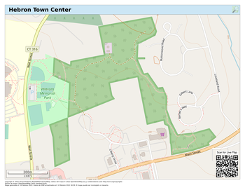
Click image above to download printable map. Trail Conditions: Trail is marked. Regular footwear Picnic tables in Veterans Park off Wall Street Trail conditions are mostly good. Mix of stone dust trails and sidewalk. Mostly in woodland and park. Part of the loop is on sidewalk. Parking: Ample parking at Veterans Memorial Park.
Parking Area
| Information: Well marked crushed stone trail includes loop around Veterans Memorial Park. Trail conditions are very good. Mix of stone dust trails and sidewalk. Mostly in woodland and park. The Town of Hebron publishes a brochure on this trail. Download brochure... Birding: Get the free Merlin Bird ID app Look and listen out for the following species which are often found
in the Hebron woodlands. Warbling Vireo, Baltimore Orioles, Yellow Warbler, Great Crested Flycatcher, American Redstart, American Robin, Catbirds, Golden-winged Warbler, Blue Jays, Grosbeak, Tufted Titmouse, Cardinals, Carolina Wren, Blue-gray Gnatcatcher, Red-winged Blackbirds, House Wren, Grackles, Wood Thrush, Yellow-throated Vireo, Red-bellied Woodpecker, Crows, Cardinals, Bluebirds, Chickadees, Veery
and various species of Hawk. Connecticut Wildflowers: Get help identifying flowers here... Plant & Tree Identification Get the free Pl@ntNet app |
Grist Mill - Chestnut Hollow Directions 
Click image above to download printable map. Trail Conditions:  Trail is not marked. Main trial is clear. Trail is not marked. Main trial is clear. Sturdy footwear recommended Picnic table by parking lot Simple paths. Generally good with a few damp areas and a couple of stream crossings. Side paths can be heavily overgrown Parking: Small parking lot and picnic table at Chestnut Hill Road entrance.
Parking Area
| Information: Hebron Views article 2024 Beautiful views over the Jeremy River and marsh at the southern end of the trail. There is a picnic table on a concrete base by the parking lot off Chestnut Hill Road Adjacent to the parking lot is the Old Town Pound, built around 1820 to hold domestic animals (cows, sheep, horses, etc.) that had strayed. Birding: This is a great trail for birding. Get the free Merlin Bird ID app Look and listen out for the following species which are often found
in the Hebron woodlands. Warbling Vireo, Baltimore Orioles, Yellow Warbler, Great Crested Flycatcher, American Redstart, American Robin, Catbirds, Golden-winged Warbler, Blue Jays, Grosbeak, Tufted Titmouse, Cardinals, Carolina Wren, Blue-gray Gnatcatcher, Red-winged Blackbirds, House Wren, Grackles, Wood Thrush, Yellow-throated Vireo, Red-bellied Woodpecker, Crows, Cardinals, Bluebirds, Chickadees, Veery
and various species of Hawk. Connecticut Wildflowers: Get help identifying flowers here... Plant & Tree Identification Get the free Pl@ntNet app |
Raymond Brook Preserve - Kinney Road Directions: Kinney Road lot Well maintained crushed stone trails. Ample parking in three lots: Church Street, Kinney Road
and Millstream Road. 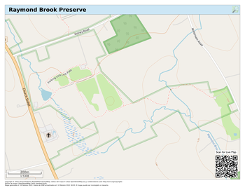
Click image above to download printable map. Trail Conditions: All trails are easy to follow. Minimal tagging needed. Regular footwear Picnic tables at Church Street entrance and by Raymond Brook bridge. Crushed stone paths. Easy to follow.
One or two damp places after heavy rain/thaw. Parking: Main parking lot off Kinney Road (above) Additional lots: Directions: Church Street lot Directions: Millstream Road lot
Kinney Road Parking Area
| Information:  Hebron Views article 2022 Hebron Views article 2022
Well maintained wide crushed stone trails in a rural park-like setting.. Two main loop trails and a spur trail to Millstream Road lot crosses Raymond Brook. Very scenic. Birding: This is a great trail for birding. Get the free Merlin Bird ID app Look and listen out for the following species which are often found
in the Hebron woodlands. Warbling Vireo, Baltimore Orioles, Yellow Warbler, Great Crested Flycatcher, American Redstart, American Robin, Catbirds, Golden-winged Warbler, Blue Jays, Grosbeak, Tufted Titmouse, Cardinals, Carolina Wren, Blue-gray Gnatcatcher, Red-winged Blackbirds, House Wren, Grackles, Wood Thrush, Yellow-throated Vireo, Red-bellied Woodpecker, Crows, Cardinals, Bluebirds, Chickadees, Veery
and various species of Hawk. Connecticut Wildflowers: Get help identifying flowers here... Plant & Tree Identification Get the free Pl@ntNet app |
Cardillo Property Directions 
Click image above to download printable map. Trail Conditions: Simple paths. No waymarking. Seasonally overgrown. Sturdy footwear recommended. No picnic facilities Parking: Main parking off Church Street (Rt. 85) opposite Mai Road
on town owned shoulder of driveway to Lutheran Church
Parking Area
| Information: Hebron Views article 2022
(Raymond Marsh protection) Simple paths with little waymarking. Can get overgrown in summer. Some great access to Raymond Marsh. Rough paths exist on the western side of the property leading to an upland section with views. Heavy going in places. Be sure to stay within the property boundary. Birding: This is a great area for birding and wildlife observation Get the free Merlin Bird ID app Look and listen out for the following species which are often found
in the Hebron woodlands. Warbling Vireo, Baltimore Orioles, Yellow Warbler, Great Crested Flycatcher, American Redstart, American Robin, Catbirds, Golden-winged Warbler, Blue Jays, Grosbeak, Tufted Titmouse, Cardinals, Carolina Wren, Blue-gray Gnatcatcher, Red-winged Blackbirds, House Wren, Grackles, Wood Thrush, Yellow-throated Vireo, Red-bellied Woodpecker, Crows, Cardinals, Bluebirds, Chickadees, Veery
and various species of Hawk. Connecticut Wildflowers: Get help identifying flowers here... Plant & Tree Identification Get the free Pl@ntNet app |
Old Hibbert Property Directions 
Click image above to download printable map. Trail Conditions: Simple paths. Mainly blaze marking rather than yellow-tags. Sturdy footwear recommended. Parking: Limited parking on shoulder of Old Colchester Road:
beware of fast traffic and park fully off the highway.
Additional parking at Air Line Trail lot.
Alternative access from Northam Road. Shoulder/road parking.
Parking Area
| | Information: Large 82-acre property of picturesque woodland with views and access to Raymond Brook.
Mainly simple paths with good access trail.
Paths are partially waymarked. Read about the Hibbert Property (pdf)... Note:
Overlook Path on the east side of Raymond Brook starts 100' south
of the Air Line Trail bench.
There is no dry crossing across Raymond Brook. Be sure to stay within the property boundary. Birding: This is a great area for birding and wildlife observation Get the free Merlin Bird ID app Look and listen out for the following species which are often found
in the Hebron woodlands. Warbling Vireo, Baltimore Orioles, Yellow Warbler, Great Crested Flycatcher, American Redstart, American Robin, Catbirds, Golden-winged Warbler, Blue Jays, Grosbeak, Tufted Titmouse, Cardinals, Carolina Wren, Blue-gray Gnatcatcher, Red-winged Blackbirds, House Wren, Grackles, Wood Thrush, Yellow-throated Vireo, Red-bellied Woodpecker, Crows, Cardinals, Bluebirds, Chickadees, Veery
and various species of Hawk. Connecticut Wildflowers: Get help identifying flowers here... Plant & Tree Identification Get the free Pl@ntNet app Background Natural Resources Inventory
Bernstein & Hibbert Open Space
November 2022 -  pdf pdf |
Bernstein Property Directions Use Judd Brook path (southside from Air Line Trail) to enjoy this site. 
Click image above to download printable map. Trail Conditions: Simple paths. Mainly blaze marking rather than yellow-tags. Sturdy footwear recommended. Parking: Limited parking on shoulder of Old Colchester Road:
beware of fast traffic and park fully off the highway.
Additional parking at Air Line Trail lot.
Alternative access from Northam Road. Shoulder/road parking.
Parking Area
| | Information: Hebron Views article 2022 (Judd Brook) Recently acquired town open space.
No established trails as of Spring 2024
Access will primarily be from lot on Old Colchester Road.
Additional access from Judd Brook and Air Line Trail. Be sure to stay within the property boundary. Birding: This is a great area for birding and wildlife observation Get the free Merlin Bird ID app Look and listen out for the following species which are often found
in the Hebron woodlands. Warbling Vireo, Baltimore Orioles, Yellow Warbler, Great Crested Flycatcher, American Redstart, American Robin, Catbirds, Golden-winged Warbler, Blue Jays, Grosbeak, Tufted Titmouse, Cardinals, Carolina Wren, Blue-gray Gnatcatcher, Red-winged Blackbirds, House Wren, Grackles, Wood Thrush, Yellow-throated Vireo, Red-bellied Woodpecker, Crows, Cardinals, Bluebirds, Chickadees, Veery
and various species of Hawk. Connecticut Wildflowers: Get help identifying flowers here... Plant & Tree Identification Get the free Pl@ntNet app Background Natural Resources Inventory
Bernstein & Hibbert Open Space
November 2022 - pdf |
Harasimowitz Property Directions Pine woodland leading to ponds.
Clear trail leading to simple path loop (no waymarking).
Limited parking on shoulder of Old Colchester Road: beware of fast traffic and park fully off the highway. 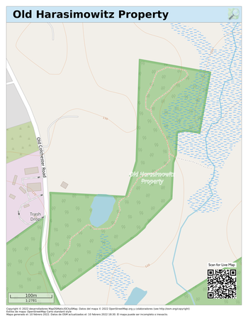
Click image above to download printable map. | Hebron Views article 2022 |
Niles Road Open Space Directions: Niles Road Directions: Pepperbush Drive Clear trail from Niles Road leading to simple unmarked path around pond to Pepperbush Drive.
Note trail from Niles Road continues into private property and path leads west before property boundary. Limited parking on shoulder of Niles Road: beware of fast traffic and park fully off the highway.
Alternative access from Pepperbush Drive: roadside parking. 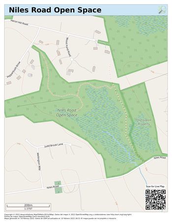
Click image above to download printable map. | |
AHM / St Peter's Preserve Directions: AHM lot 
Click image above to download printable map. Trail Conditions: Trail is not tagged. Main trial is clear. Regular footwear Simple paths. Generally good with a few damp areas and a couple of stream crossings. Side paths can be heavily overgrown Parking: Ample parking off Pendleton Drive at AHM lot (above). Directions: Church lot and at Church lot (except during services).
Church Street Parking Area
| Information: Well marked wide paths through large wooded lot.
Paths on this property are by the courtesy of St Peter's Church.
South side loop can be wet after rain/thaw and be overgrown in summer. Access to Horton Land fields (Town Property) and through to Raymond Brook.
No formal trail (Spring 025) A haven of peace near the Town Center. A simple loop can be made using the Church Street and Main Street sidewalks Birding: This is a great trail for birding. Get the free Merlin Bird ID app Look and listen out for the following species which are often found
in the Hebron woodlands. Warbling Vireo, Baltimore Orioles, Yellow Warbler, Great Crested Flycatcher, American Redstart, American Robin, Catbirds, Golden-winged Warbler, Blue Jays, Grosbeak, Tufted Titmouse, Cardinals, Carolina Wren, Blue-gray Gnatcatcher, Red-winged Blackbirds, House Wren, Grackles, Wood Thrush, Yellow-throated Vireo, Red-bellied Woodpecker, Crows, Cardinals, Bluebirds, Chickadees, Veery
and various species of Hawk. Connecticut Wildflowers: Get help identifying flowers here... Plant & Tree Identification Get the free Pl@ntNet app |
Highland Drive Directions Mint Brook Preserve.
Paths through wooded area. Mostly easy to follow. Roadside parking. 
Click image above to download printable map. | |
Yaps Property / Hebron Elementary Directions No established paths at Yaps Property in Spring 2024
Access to Hebron Elementary only when school is not in session. Parking at Hebron Elementary only when school is not in session. 
Click image above to download printable map. | |
No established paths at Yaps Property in Spring 2024
Access to Hebron Elementary only when school is not in session. Parking at Hebron Elementary only when school is not in session.
Click image above to download printable map.
Old Slocum Road Directions Discontinued town road between CT DEEP State Forest wooded areas. Easy to follow.
Attractive views of Fawn Brook. Rough surface in places. Off road parking at corner of Slocum Rd and Blackman Rd 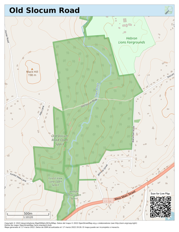
Click image above to download printable map. | |
Salmon River State Forest - north Directions: TH West Directions: TH East Extensive biking and hiking trails on DEEP State Forest and
Connecticut River Watershed Council land.
NOT a Hebron Town property: any issues should be addressed to DEEP Trailhead (TH) access from Hope Valley Rd W & E.
Small parking lot and roadside parking at W trailhead.
Small roadside parking area just north of E trailhead on Hope Valley Rd: approach from the north. No safe turnaround. East section: simple paths (no bikes) and Jeremy River access from trailhead on Reidy Hill Rd,
0.2m south of Northam Rd (near top of the hill). 
Click image above to download printable map. | |
Salmon River State Forest - south Directions Extensive biking and hiking trails on DEEP State Forest land.
Connects northwards to Connecticut River Watershed Council land.
Mostly not on Hebron Town property: any issues should be addressed to DEEP Main parking Grayville Park parking lot at end of Reidy Hill Rd. Trailhead is 500 feet west of parking lot (beyond the bridge),
continuing from end of paved section of Grayville Road.
Small parking lot at turnaround.
Do not block access to residences & be a good neighbor. 
Click image above to download printable map. | |
Sliding zoomable map of Hebron | Hebron PathsMaps of Paths and TrailsSelect site maps belowScroll to bottom of page for overall map Jagger Lane Open Space  Directions Directions 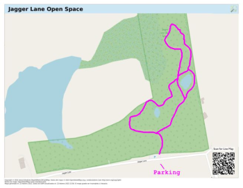
Click image for a live map. Trail Conditions: Trail is marked. Sturdy footwear recommended Trail conditions are mostly good with a couple of muddy
places including by the entrance. Otherwise generally mown grass. Parking: Parking in a dedicated roadside lot and on shoulder of Jagger Lane away from the intersection.
Parking Area
| Information:
Also known as the old 'Way Property'. Simple paths.
This 32-acre property, is "L" shaped extending along Jagger Lane from its intersection of Hardy Road to the west with approximately 1,200 feet of road frontage. It is located within the Fawn Brook Greenway.
A section of the property is used for farm operations (grazing) as its primary feature is grassland.
Other natural features include a picturesque shallow pond; areas of deciduous woodlands, wetlands and rolling hills, providing a scenic view of Merrow Swamp.
Merrow Swamp, a Wetlands of Statewide Special Concern, is located at the northern end of the parcel and is the headwaters of Fawn Brook, a Class A watercourse. The Property is host to Species of Special Concern at this northern end.
A system of trails extends from the Jagger Lane entrance north to the property’s pond and to the Merrow Swamp at the northern end of the parcel and then winds its way to the property’s westerly end.
Birding:
Get the free Merlin Bird ID app
Look and listen out for the following species which are often found
in the Hebron woodlands.
Warbling Vireo, Baltimore Orioles, Yellow Warbler, Great Crested Flycatcher, American Redstart, American Robin, Catbirds, Golden-winged Warbler, Blue Jays, Grosbeak, Tufted Titmouse, Cardinals, Carolina Wren, Blue-gray Gnatcatcher, Red-winged Blackbirds, House Wren, Grackles, Wood Thrush, Yellow-throated Vireo, Red-bellied Woodpecker, Crows, Cardinals, Bluebirds, Chickadees, Veery
and various species of Hawk.
Connecticut Wildflowers:
Get help identifying flowers here...
Plant & Tree Identification
Get the free Pl@ntNet app
[-] To close... |
Burnt Hill Directions 
Click on image for LIVE map. Other maps:
Burnt Hill Park 3-Mile Course Trail Conditions: Trail (woodland loop) is marked. Regular footwear   Picnic tables available Picnic tables available Trail conditions are mostly good. Mix of stone dust trails and well-made
woodland paths. Some grass and meadow walking. Parking: Ample parking in marked lots.
Parking Area
Information:
Mix of crushed stone trails, woodland trails and simple paths.
Burnt Hill Park, includes five athletic fields and amenities including a park operations building, pavilion, bathroom building and walking trails, and was constructed in 2008-2009. The park is a great example of a multi-use facility which incorporates recreational athletic fields in a park like setting consistent with the rural character and nature of the Town of Hebron.
The park provides all weather walking trails, a woodland loop trail, a woodland path extension and several meadow paths.
Burnt Hill Park is also home to the Peters House (open on event days). Cesar and Lowis Peters were enslaved African Americans who lived in Hebron, Connecticut, in the late 18th century. While the story of how they survived as slaves contributes greatly to the underappreciated history of slavery in Connecticut, the story of how they gained their freedom reveals much about transformations in popular thinking about race, slavery, and liberty during the era of the American Revolution. (Continue reading here...)
Hebron Historical Report here...
Birding:
Get the free Merlin Bird ID app
Look and listen out for the following species which are often found
in the Hebron woodlands.
Warbling Vireo, Baltimore Orioles, Yellow Warbler, Great Crested Flycatcher, American Redstart, American Robin, Catbirds, Golden-winged Warbler, Blue Jays, Grosbeak, Tufted Titmouse, Cardinals, Carolina Wren, Blue-gray Gnatcatcher, Red-winged Blackbirds, House Wren, Grackles, Wood Thrush, Yellow-throated Vireo, Red-bellied Woodpecker, Crows, Cardinals, Bluebirds, Chickadees, Veery
and various species of Hawk.
Connecticut Wildflowers:
Get help identifying flowers here...
Plant & Tree Identification
Get the free Pl@ntNet app
[-] Back
Holbrook Pond Directions: Ridge Road 
Click on image for LIVE map. Trail Conditions: Trail is marked. Sturdy footwear recommended Wet sections after thaw or heavy rain Parking: Parking spaces for 50 cars on DEEP site at end of Holbrook Pond Road.
There is also shoulder parking on Ridge Road.
Parking Area
Information:
This location is part CT DEEP land managed as part of Gay City State Park.
DEEP Site... here
Town land has simple paths from Ridge Road. Trail conditions are mostly clear and good. Some rocky spots and muddy sections depending on weather.
Birding:
Get the free Merlin Bird ID app
Look and listen out for the following species which are often found
in the Hebron woodlands.
Warbling Vireo, Baltimore Orioles, Yellow Warbler, Great Crested Flycatcher, American Redstart, American Robin, Catbirds, Golden-winged Warbler, Blue Jays, Grosbeak, Tufted Titmouse, Cardinals, Carolina Wren, Blue-gray Gnatcatcher, Red-winged Blackbirds, House Wren, Grackles, Wood Thrush, Yellow-throated Vireo, Red-bellied Woodpecker, Crows, Cardinals, Bluebirds, Chickadees, Veery
and various species of Hawk.
Connecticut Wildflowers:
Get help identifying flowers here...
Plant & Tree Identification
Get the free Pl@ntNet app
Title displayed when panel collapsed
Town Center Directions 
Click on image for LIVE map. Trail Conditions: Trail is marked. Regular footwear Picnic tables in Veterans Park off Wall Street. Trail conditions are mostly good. Mix of stone dust trails and sidewalk. Mostly in woodland and park. Part of the loop is on sidewalk. Parking: Ample parking at Veterans Memorial Park.
Parking Area
Information:
Well marked crushed stone trail includes loop around Veterans Memorial Park.
Trail conditions are very good. Mix of stone dust trails and sidewalk. Mostly in woodland and park.
The Town of Hebron publishes a brochure on this trail. Download brochure...
Birding:
Get the free Merlin Bird ID app
Look and listen out for the following species which are often found
in the Hebron woodlands.
Warbling Vireo, Baltimore Orioles, Yellow Warbler, Great Crested Flycatcher, American Redstart, American Robin, Catbirds, Golden-winged Warbler, Blue Jays, Grosbeak, Tufted Titmouse, Cardinals, Carolina Wren, Blue-gray Gnatcatcher, Red-winged Blackbirds, House Wren, Grackles, Wood Thrush, Yellow-throated Vireo, Red-bellied Woodpecker, Crows, Cardinals, Bluebirds, Chickadees, Veery
and various species of Hawk.
Connecticut Wildflowers:
Get help identifying flowers here...
Plant & Tree Identification
Get the free Pl@ntNet app
Title displayed when panel collapsed
Grist Mill - Chestnut Hollow Directions 
Click on image for LIVE map. Trail Conditions: Trail is not marked. Main trial is clear. Sturdy footwear recommended Picnic table by parking lot Simple paths. Generally good with a few damp areas and a couple of stream crossings. Side paths can be heavily overgrown Parking: Small parking lot and picnic table at Chestnut Hill Road entrance.
Parking Area
Information:
Beautiful views over the Jeremy River and marsh at the southern end of the trail.
There is a picnic table on a concrete base by the parking lot off Chestnut Hill Road
Adjacent to the parking lot is the Old Town Pound, built around 1820 to hold domestic animals (cows, sheep, horses, etc.) that had strayed.
Birding:
This is a great trail for birding.
Get the free Merlin Bird ID app
Look and listen out for the following species which are often found
in the Hebron woodlands.
Warbling Vireo, Baltimore Orioles, Yellow Warbler, Great Crested Flycatcher, American Redstart, American Robin, Catbirds, Golden-winged Warbler, Blue Jays, Grosbeak, Tufted Titmouse, Cardinals, Carolina Wren, Blue-gray Gnatcatcher, Red-winged Blackbirds, House Wren, Grackles, Wood Thrush, Yellow-throated Vireo, Red-bellied Woodpecker, Crows, Cardinals, Bluebirds, Chickadees, Veery
and various species of Hawk.
Connecticut Wildflowers:
Get help identifying flowers here...
Plant & Tree Identification
Get the free Pl@ntNet app
Title displayed when panel collapsed
Raymond Brook Preserve - Kinney Road Directions: Church Street lot Well maintained crushed stone trails. Ample parking in three lots. 
Click on image for LIVE map. Trail Conditions: All trails are easy to follow. Minimal tagging needed.  Regular footwear Regular footwear Picnic tables by Church Street entrance and by Raymond Brook bridge. Crushed stone paths. Easy to follow.
One or two damp places after heavy rain/thaw. Parking:  Main parking lot off Kinney Road Main parking lot off Kinney Road Additional lots:  Directions: Church Street lot Directions: Church Street lot
Directions: Millstream Road lot 
Kinney Road Parking Area
Information:

Hebron Views article 2022
Well maintained wide crushed stone trails in a rural park-like setting. Two main loop trails and a spur trail to Millstream Road lot crosses Raymond Brook. Very scenic.
Birding:
This is a great trail for birding.
 Get the free Merlin Bird ID app Get the free Merlin Bird ID app
Look and listen out for the following species which are often found
in the Hebron woodlands.
Warbling Vireo, Baltimore Orioles, Yellow Warbler, Great Crested Flycatcher, American Redstart, American Robin, Catbirds, Golden-winged Warbler, Blue Jays, Grosbeak, Tufted Titmouse, Cardinals, Carolina Wren, Blue-gray Gnatcatcher, Red-winged Blackbirds, House Wren, Grackles, Wood Thrush, Yellow-throated Vireo, Red-bellied Woodpecker, Crows, Cardinals, Bluebirds, Chickadees, Veery
and various species of Hawk.
Connecticut Wildflowers:
 Get help identifying flowers here... Get help identifying flowers here...
Plant & Tree Identification
 Get the free Pl@ntNet app Get the free Pl@ntNet app
Cardillo Property Directions Simple paths with little waymarking. Parking on town owned shoulder of driveway to Lutheran Church opposite Mai Road. 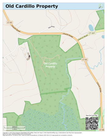
Click on image for LIVE map.
Old Hibbert Property Directions 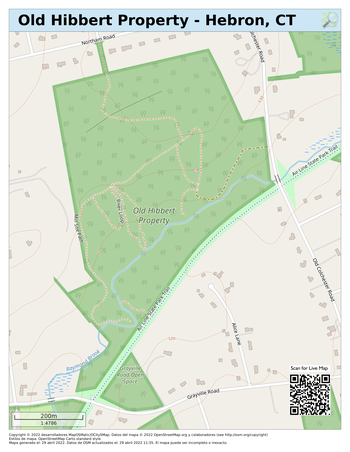
Click on image for LIVE map. Trail Conditions: Simple paths. Mainly blaze marking rather than yellow-tags. Sturdy footwear recommended. Parking: Limited parking on shoulder of Old Colchester Road:
beware of fast traffic and park fully off the highway.
Additional parking at Air Line Trail lot.
Alternative access from Northam Road. Shoulder/road parking.
Parking Area
Information:
Large 82-acre property of picturesque woodland with views and access to Raymond Brook.
Mainly simple paths with good access trail.
Paths are partially waymarked.
Read about the Hibbert Property (pdf)...
Note:
Overlook Path on the east side of Raymond Brook starts 100' south
of the Air Line Trail bench.
There is no dry crossing across Raymond Brook.
Be sure to stay within the property boundary.
Birding:
This is a great area for birding and wildlife observation
Get the free Merlin Bird ID app
Look and listen out for the following species which are often found
in the Hebron woodlands.
Warbling Vireo, Baltimore Orioles, Yellow Warbler, Great Crested Flycatcher, American Redstart, American Robin, Catbirds, Golden-winged Warbler, Blue Jays, Grosbeak, Tufted Titmouse, Cardinals, Carolina Wren, Blue-gray Gnatcatcher, Red-winged Blackbirds, House Wren, Grackles, Wood Thrush, Yellow-throated Vireo, Red-bellied Woodpecker, Crows, Cardinals, Bluebirds, Chickadees, Veery
and various species of Hawk.
Connecticut Wildflowers:
Get help identifying flowers here...
Plant & Tree Identification
Get the free Pl@ntNet app
Background
Natural Resources Inventory
Bernstein & Hibbert Open Space
November 2022 -  pdf pdf
Title displayed when panel collapsed |
Bernstein Property Directions Use Judd Brook path (southside from Air Line Trail) to enjoy this site. 
Click on image for LIVE map. Trail Conditions: No clear paths in main part of this site (Spring 2025).
Judd Brook trail clear from AirLine Trail. Sturdy footwear recommended in main part of site.   Heavily overgrown in many places. Heavily overgrown in many places. Regular footwear OK for Judd Brook trail Parking: Judd Brook parking at Air Line Trail / Grayville Falls lot. (Recommended)
Alternative at Air Line Trail parking on Grayville Rd.
Dedicated parking lot off Old Colchester Road
but NO trail access (Spring 2025).
Parking Area
Information:
Hebron Views article 2022 (Judd Brook trail)
Recently acquired town open space.
Access this property by walking along the Air Line Trail. The Judd Brook trail is an old rail spur that Y's off to the east, just north of the Judd Brook bridge.
No other established trails as of Spring 2025
Access will in future be from lot on Old Colchester Road.
Additional access from Judd Brook and Air Line Trail.
Be sure to stay within the property boundary.
Birding:
This is a great area for birding and wildlife observation
Get the free Merlin Bird ID app
Look and listen out for the following species which are often found
in the Hebron woodlands.
Warbling Vireo, Baltimore Orioles, Yellow Warbler, Great Crested Flycatcher, American Redstart, American Robin, Catbirds, Golden-winged Warbler, Blue Jays, Grosbeak, Tufted Titmouse, Cardinals, Carolina Wren, Blue-gray Gnatcatcher, Red-winged Blackbirds, House Wren, Grackles, Wood Thrush, Yellow-throated Vireo, Red-bellied Woodpecker, Crows, Cardinals, Bluebirds, Chickadees, Veery
and various species of Hawk.
Connecticut Wildflowers:
Get help identifying flowers here...
Plant & Tree Identification
Get the free Pl@ntNet app
Background
Natural Resources Inventory
Bernstein & Hibbert Open Space
November 2022 - pdf
Title displayed when panel collapsed
Harasimowitz Property Directions Pine woodland leading to ponds.
Clear trail leading to simple path loop (no waymarking).
Limited parking on shoulder of Old Colchester Road: beware of fast traffic and park fully off the highway. 
Click on image for LIVE map.
Niles Road Open Space Directions: Niles Road Directions: Pepperbush Drive Clear trail from Niles Road leading to simple unmarked path around pond to Pepperbush Drive.
 Note Track from Niles Road continues into private property. Stop! Path leads west before property boundary: pay attention! Note Track from Niles Road continues into private property. Stop! Path leads west before property boundary: pay attention! Limited parking on shoulder of Niles Road: beware of fast traffic and park fully off the highway.
Alternative access from Pepperbush Drive: roadside parking. 
Click on image for LIVE map.
AHM / St Peter's Preserve Directions: AHM lot 
Click on image for LIVE map. Trail Conditions: Trail is not tagged. Main trial is clear. Regular footwear One main trail from AHM access to Church lot, otherwise simple paths. Generally good with a few damp areas and a couple of stream crossings. Side paths can be heavily overgrown in summer. Parking: Ample parking off Pendleton Drive at AHM lot (above),
and at Church lot (except during services). Directions: Church lot
Church Street Parking Area
Information:
Well marked wide paths through large wooded lot.
Paths on this property are by the courtesy of St Peter's Church.
South side loop can be wet after rain/thaw and be overgrown in summer.
Access to Horton Land fields (Town Property) and through to Raymond Brook.
No formal trail over fields (Spring 025)
A haven of peace near the Town Center. A simple loop can be made using the Church Street and Main Street sidewalks
Birding:
This is a great trail for birding.
Get the free Merlin Bird ID app
Look and listen out for the following species which are often found
in the Hebron woodlands.
Warbling Vireo, Baltimore Orioles, Yellow Warbler, Great Crested Flycatcher, American Redstart, American Robin, Catbirds, Golden-winged Warbler, Blue Jays, Grosbeak, Tufted Titmouse, Cardinals, Carolina Wren, Blue-gray Gnatcatcher, Red-winged Blackbirds, House Wren, Grackles, Wood Thrush, Yellow-throated Vireo, Red-bellied Woodpecker, Crows, Cardinals, Bluebirds, Chickadees, Veery
and various species of Hawk.
Connecticut Wildflowers:
Get help identifying flowers here...
Plant & Tree Identification
Get the free Pl@ntNet app
Highland Drive Directions Paths through wooded area. Mostly easy to follow. Roadside parking. 
Click on image for LIVE map.
Yaps Property / Hebron Elementary Directions No established paths at Yaps Property in Spring 2024
Access to Hebron Elementary only when school is not in session. Parking at Hebron Elementary only when school is not in session. 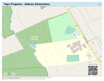
Click on image for LIVE map.
Old Slocum Road Directions Discontinued town road between CT DEEP State Forest wooded areas. Easy to follow.
Attractive views of Fawn Brook. Rough surface in places. Off road parking at corner of Slocum Rd and Blackman Rd 
Click image for LIVE map.
Salmon River State Forest - north Directions: TH West Directions: TH East Extensive biking and hiking trails on DEEP State Forest and
Connecticut River Watershed Council land.
NOT a Hebron Town property: any issues should be addressed to DEEP Trailhead (TH) access from Hope Valley Rd W & E.
Small parking lot and roadside parking at W trailhead.
Small roadside parking area just north of E trailhead on Hope Valley Rd: approach from the north. No safe turnaround. East section: simple paths (no bikes) and Jeremy River access from trailhead on Reidy Hill Rd,
0.2m south of Northam Rd (near top of the hill). 
Click image for LIVE map.
Salmon River State Forest - south Directions Extensive biking and hiking trails on DEEP State Forest land.
Connects northwards to Connecticut River Watershed Council land.
Mostly not on Hebron Town property: any issues should be addressed to DEEP Main parking Grayville Park parking lot at end of Reidy Hill Rd. Trailhead is 500 feet west of parking lot (beyond the bridge),
continuing from end of paved section of Grayville Road.
Small parking lot at turnaround.
Do not block access to residences & be a good neighbor. 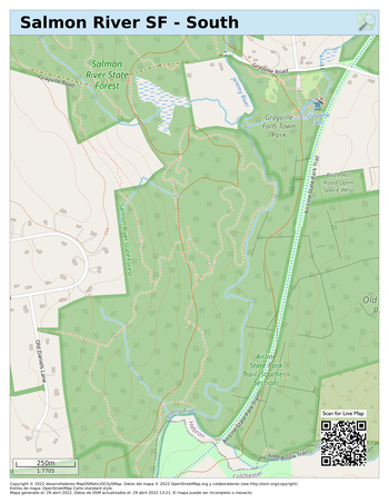
Click image for LIVE map.
Sliding zoomable map of Hebron | Hebron PathsMaps of Paths and Trails
Select site maps below
 Click this icon to open a live map Click this icon to open a live map
Jagger Lane Open Space  Directions Directions Also known as the old 'Way Property'. Simple paths Parking in a dedicated roadside lot and on shoulder of
Jagger Lane away from the intersection. 
Click image above to download printable map.  Trail Conditions   Sturdy footwear recommended Sturdy footwear recommended
Trail conditions for June 1, 2024 are good with a couple of muddy places
including by the entrance. Otherwise generally mown grass. | 
Parking area
About This 32-acre property, is "L" shaped extending along Jagger Lane from its intersection of Hardy Road to the west with approximately 1,200 feet of road frontage. It is located within the Fawn Brook Greenway. A section of the property is used for farm operations (grazing) as its primary feature is grassland. Other natural features include a picturesque shallow pond; areas of deciduous woodlands, wetlands and rolling hills, providing a scenic view of Merrow Swamp.
Merrow Swamp, a Wetlands of Statewide Special Concern, is located at the northern end of the parcel and is the headwaters of Fawn Brook, a Class A watercourse. The Property is host to Species of Special Concern at this northern end. A system of trails extends from the Jagger Lane entrance north to the property’s pond and to the Merrow Swamp at the northern end of the parcel and then winds its way to the property’s westerly end. Birding: Get the free Merlin Bird ID app Look and listen out for the following species. Warbling Vireo, Baltimore Orioles, Yellow Warbler, Great Crested Flycatcher, American Redstart, American Robin, Catbirds, Golden-winged Warbler, Blue Jays, Grosbeak, Tufted Titmouse, Cardinals, Carolina Wren, Blue-gray Gnatcatcher, Red-winged Blackbirds, House Wren, Grackles, Wood Thrush, Yellow-throated Vireo, Red-bellied Woodpecker, Crows, Cardinals, Bluebirds, Chickadees, Veery and various species of Hawk. Connecticut Wildflowers Get help identifying flowers here... Plant & Tree Identification Get the free Pl@ntNet app |
Burnt Hill Directions Mix of crushed stone trails, woodland trails and simple paths. Ample parking in marked lots. 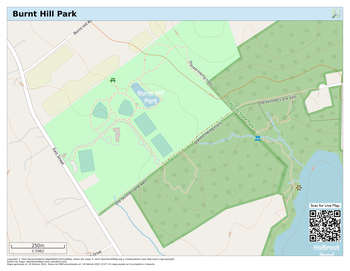
Click image to download printable map. Other maps: Burnt Hill Park 3-Mile Course
Holbrook Pond Directions: Ridge Road This location is part CT DEEP land managed as part of Gay City State Park. DEEP Site... Town land has simple paths from Ridge Road. Parking spaces for 50 cars on DEEP site. Shoulder parking on Ridge Road. 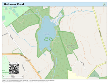
Click image to download printable map.
Town Center Directions Well marked crushed stone trail includes loop around Veterans Memorial Park. Ample parking at Veterans Memorial Park. The Town of Hebron publishes a brochure on this trail. Download brochure... 
Click image to download printable map.
Grist Mill - Chestnut Hollow Directions Simple paths Small parking lot and picnic table at Chestnut Hill Road entrance. 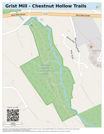
Click image to download printable map.
Cardillo Property Directions Simple paths with little waymarking. Parking on town owned shoulder of driveway to Lutheran Church opposite Mai Road. 
Click image to download printable map.
Old Hibbert Property Directions Large property of picturesque woodland with views and access to Raymond Brook.
Mainly simple paths with good access trail.
Paths are partially waymarked. Overlook Path starts 100' south of the Air Line Trail bench.
There is no access across Raymond Brook. Limited parking on shoulder of Old Colchester Road: beware of fast traffic and park fully off the highway.
Additional parking at Air Line Trail lot.
Alternative access from Northam Road. Shoulder/road parking. 
Click image to download printable map.
Bernstein Property Directions Recently acquired town open space.
No established trails as of Spring 2024
Access primarily from Old Colchester Road lot. Additional access from Judd Brook and Air Line Trail. 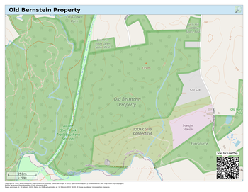
Click image to download printable map.
Harasimowitz Property Directions Pine woodland leading to ponds.
Clear trail leading to simple path loop (no waymarking).
Limited parking on shoulder of Old Colchester Road: beware of fast traffic and park fully off the highway. 
Click image to download printable map.
Niles Road Open Space Directions: Niles Road Directions: Pepperbush Drive Clear trail from Niles Road leading to simple unmarked path around pond to Pepperbush Drive.
Note trail from Niles Road continues into private property and path leads west before property boundary. Limited parking on shoulder of Niles Road: beware of fast traffic and park fully off the highway.
Alternative access from Pepperbush Drive: roadside parking. 
Click image to download printable map.
AHM / St Peter's Preserve Directions: AHM lot Directions: Church lot Well marked wide paths through large wooded lot.
Paths on this property are by the courtesy of St Peter's Church. Ample parking off Pendleton Drive and at Church lot (except during services). 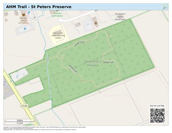
Click on image for LIVE map.
Highland Drive Directions Paths through wooded area. Mostly easy to follow. Roadside parking. 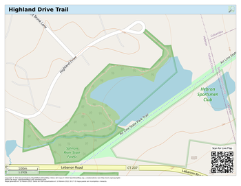
Click on image for LIVE map.
Yaps Property / Hebron Elementary Directions No established paths at Yaps Property in Spring 2022
Access to Hebron Elementary only when school is not in session. Parking at Hebron Elementary only when school is not in session. 
Click on image for LIVE map.
Old Slocum Road Directions Discontinued town road between CT DEEP State Forest wooded areas. Easy to follow.
Attractive views of Fawn Brook. Rough surface in places. Off road parking at corner of Slocum Rd and Blackman Rd 
Click image to download printable map.
Salmon River State Forest - north Directions: TH West Directions: TH East Extensive biking and hiking trails on DEEP State Forest and
Connecticut River Watershed Council land.
NOT a Hebron Town property: any issues should be addressed to DEEP Parking Grayville Park.
Trailhead access from Hope Valley Rd W & E.
Small parking lot and roadside parking at W trailhead.
Small roadside parking area just north of E trailhead on Hope Valley Rd: approach from the north. No turnaround. East section: simple paths (no bikes) and Jeremy River access from trailhead on Reidy Hill Rd,
0.2m south of Northam Rd (near top of the hill). 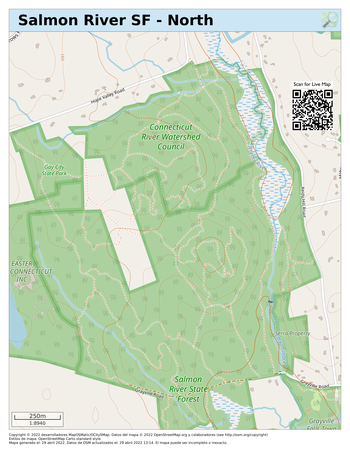
Click image to download printable map.
Salmon River State Forest - south Directions Extensive biking and hiking trails on DEEP State Forest land.
Connects northwards to Connecticut River Watershed Council land.
Mostly not on Hebron Town property: any issues should be addressed to DEEP Parking Grayville Park parking lot at end of Reidy Hill Rd.
Trailhead from end of paved section of Grayville Road.
Small parking lot at trailhead.
Do not block access to residences & be a good neighbor. 
Click image to download printable map.
Sliding zoomable map of Hebron |
|
|


