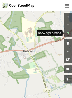
We are in the process of creating user maps for each of the town of Hebron properties that has walkable paths or trails.
Paths are simple ways made by feet on the ground. Trails are more formal with made surfaces of crushed stone or similar.
Some sites have parking lots and clearly waymarked routes, and others use shoulder parking and the routes are not marked.
It is all a work in progress, but enjoy using these resources to walk the paths and trails on your town's land.
The Open Space map above marks the mapped Sites around town. They are also listed on the Maps page.
Each site has a map that you can download and print out to take with you to help find your way around.
Each map has a QR code like this:

When you get to the Site, scan the QR code on the map with your smartphone and a live map will open for you.
Click the 'Show My Location' link on the right-menu and the map will show you approximately where you are.


Be Bear Aware
Black bears are increasingly common in Connecticut, including Hebron.
Here is the DEEP advice on hiking in our state.
BEARS SEEN WHEN HIKING OR CAMPING
Bears in natural settings normally leave an area once they have sensed a human. If you see a bear, enjoy it from a distance.
Aggression by bears towards humans is exceptionally rare.
What to do:
Hike in groups and make noise periodically.
If you see a bear before it sees you, do not approach the bear. Stay still and then back away quietly.
If you encounter a bear while hiking and it is aware of you, make your presence known by yelling or making other loud noises. Wave your arms over your head. Back away slowly and do not run or climb a tree. If the bear keeps approaching you, use bear spray (make sure you know how to use bear spray before heading out on your hike). Black bears rarely attack humans. If you are attacked, do not play dead. Fight back aggressively with anything available.
Keep dogs on a short leash when walking and hiking. This is for the safety of your dog, yourself, and the bear. A roaming dog might be perceived as a threat to a bear or its cubs.
What next?

The next part of the plan is to mark the paths and trails with easy to see 'way-markers'. Hopefully you will have seen these trails being marked, we started in the Fall of 2022 - of course you can use these maps to explore on your own!


